WINTER walking in our beautiful countryside has a special charm and on crisp sunlit days in West Somerset and Exmoor we are spoiled for choice - hills, moors and coastal vistas beckon invitingly and often, at this time of year, you could almost have the stunning landscape to yourself.
Over the past 20 years, I’ve explored over 1,000 Westcountry walks on more than of 5,000 miles of stunning countryside, and here are just a few local routes which are ideal for winter walking. So lace up your boots, pick up your stick and let’s get going.
Blue Anchor - Dunster circular

.jpeg?trim=0,202,0,418&width=752&height=500&crop=752:500)
The start of this walk is near Blue Anchor station. Across the railway, a public footpath will take you across the meadows to Carhampton.
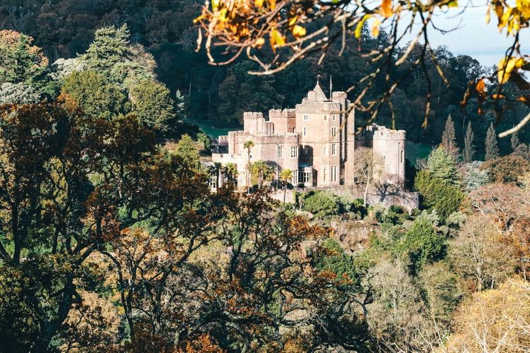
We walk up High Street to turn right into Park Lane and begin the gentle ascent which continues west out of the village to Dunster Deer Park. The paved lane gives way to rough track and, where it turns sharp, left you'll see a gate straight ahead that leads into Dunster Deer Park. This is a particularly beautiful section, offering excellent views of the famous castle.
We dip into the valley to cross the River Avill at much-photographed Gallox Bridge. From here we can either stroll through the village on our return to the Minehead road or walk down the riverside footpath and across Dunster Lawns.
Having crossed the road to the Marsh area of the village it's simply a matter of making our way to Dunster Beach where we can turn right along the new multi-purpose path and enjoy the coastal stroll back to Blue Anchor.
Bicknoller-Weacombe circular - the Quantock Hills
.jpeg?width=752&height=500&crop=752:500)
.jpeg?width=752&height=500&crop=752:500)
This is one of the best short walks in the area. The basic hike starts at Bicknoller and runs along the fringe of the hills to Weacombe, then turns up that valley to Bicknoller Post before returning down Bicknoller Combe.
At Bicknoller you’re best advised to park down in the village because there’s not much room in the lane that leads up to the combe. Walk up to the entrance of the valley and turn left and take the footpath that fringes the hills as it heads for Weacombe and gives wonderful views of the Vale of West Somerset.
Weacombe announces itself with the dramatic abruptness that is typical in hills carved out of soft red sandstone. The combe is deep and steep and we turn into it and proceed up the stream-side. Up-and-up Weacombe goes, to eventually fork at its upper end. We take the right hand path and climb to Bicknoller Post.
On the main ridge of the Quantock Hills we enjoy amazing 360-degree panoramas. Turn right and keep right when it comes to the various tracks which would take us further along the ridge. What we’re looking for is the next big groove that falls away from the hills to our right, for this is Bicknoller Combe.
All we have to do is walk down it to find the place where we started - or, better still, to continue into Bicknoller and the pub!
Heddon’s Mouth - Woody Bay circular - Exmoor Coast
.jpeg?trim=90,0,17,0&width=752&height=500&crop=752:500)

This hike features in my top ten wonderful West Country walks. The first part is down the lower part of Heddon's Mouth Cleave - one of the steepest, deepest valleys to be found on Exmoor.
You can park near the pub in the small car park opposite the National Trust visitor centre. Walk past the inn and follow the road around the bottom of the valley towards Trentishoe. After 300 metres you will see the footpath leading to the beach on your right.
It's a riverside mile down to the sea - one of the most dramatic miles in England. In 1827 a local farmer called Jim Hoyle was caught with no fewer than £1,180's worth of brandy hidden under his stable floors. Customs and Excise confiscated the 262 tubs of booze, but lucky Jim escaped through a back window.
Now we cross the river to find the coast path which heads in an easterly direction - albeit vertically - out of the valley on a section which is not for vertigo sufferers. Eventually there's a climb through the woods towards the upper section of the scattered community of Woody Bay.
Eventually we reach the old carriageway near Woody Bay, where we turn right back towards Heddon's Mouth to enjoy the breathtaking views that sweep across the Bristol Channel.
Along the way we pass the remains of the Roman signal-station in which Italian soldiers must have once frozen on guard-duty. After that the track turns into the massive Cleave and takes you dramatically back to Hunters Inn.
Luxborough circular

Luxborough offers some of the best walking country in the area. The three-part community - consisting of Kingsbridge, Pooltown and Churchtown - is surrounded by forests and hills. But Kingsbridge (where the pub is) is as good a place as any to start and finish because there’s a car park situated at the village hall.
We took the lane south from the hall to Pooltown and then swung right up the steep road that's marked Dunster. After about 400 metres a track descends left off the road, just opposite Hall Farm.
This leads down, over a stream, past an attractive cottage and then swings due west to ascend gently through some delightful meadows. High above, on a shelf on the side of the hill, you'll see splendid old Chargot Manor nestling beneath its giant cedar tree.
The track continues on to Chargot Wood. Take the first forestry track on the right which turns back on itself to climb the slope westwards toward Collyhill Wood.
We are now high on Kennisham Hill, in an entire area riddled with iron mines a century or more ago. You may catch a glimpse of an old chimney stack high above Chargot Wood.
Lype Common lies just to the west of Kennisham and is criss-crossed with public rights-of-way. We descend due north to find the track that crosses directly to Luxborough's Churchtown.
By turning left, or west, at the church, we walk a few hundred yards up the lane to find the footpath that heads north across three fields to eventually arrive at a wide track.
Turning right here we can make the gentle climb to yet more vast pinewoods - this time we enter the great plantations which crown massive Croydon Hill.
At a crossroads of tracks on the edge of Withycombe Common we turn sharp right to begin our descent down the eastern edge of Perley Combe, and eventually arrive at what used to be the Forestry Commission’s local headquarters. From here it’s simply a matter of walking the last quarter of a mile back to Kingsbridge and the pub…
You can see more images and read more about Martin’s walks at www.martinhespfoodandtravel.com


Comments
This article has no comments yet. Be the first to leave a comment.