THE Met Office warns of changeable weather over the Easter weekend with the potential for both ‘disruptive’ periods of heavy rain and spells of sunshine,
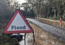
Following a wet and windy night for some, Dartmoor saw around 70 mm of rainfall while the A358 in Williton, West Somerset, was closed by a fallen tree, that band of rain is slowly moving north across the UK today.
Showers may be heavy at times, with the west and north experiencing the wettest conditions. A yellow warning for rain is still in place for Northern Ireland, while a similar warning for Cornwall, Devon, parts of Somerset and Wales, expired at around lunchtime today (Wednesday, April 16).
Brighter conditions will follow across the South, with a few showers developing. It will also be a blustery day for many, feeling chilly under the cloud and rain. This evening will feel cool, with some rural frost developing.


Tomorrow looks to be a drier and brighter day for many, feeling a little warmer in any sunshine. There will be some showers around, mainly in the South and West, which could be heavy in places. Parts of Scotland could see outbreaks of rain linger in places for most of the day.
Yellow weather warning issued
— Met Office (@metoffice) April 14, 2025
Rain across Wales and western parts of England
Tuesday 1200 – 1200 Wednesday
Latest info https://t.co/QwDLMfRBfs
Stay #WeatherAware pic.twitter.com/KRwTlyKS2l
As we enter the Bank Holiday weekend, the weather is set to be changeable, and is certainly in contrast to the wall-to-wall sunshine we experienced last weekend.
Deputy chief meteorologist Steven Skeates said: “The Easter weekend is set to bring changeable weather for many. Some areas may experience near dry conditions all weekend, whilst others may see heavy rain.
“We are keeping a close eye on an area of low pressure which sinks away to the south on Friday. This could bring with it some heavy, and possibly even disruptive rain for parts of South West England, and also parts of Northern Ireland and south Wales. This will bring the potential for some difficult travelling conditions, with a lot of spray on the roads, and it’s important people keep an eye on our forecast as things evolve over the coming day or so.
“The low will pull away to the South on Saturday, although the speed and time of the clearance is rather uncertain at the moment. Some rain may linger across parts of the West South West but elsewhere, many parts will enjoy some sunny spells, with light winds and temperatures around average.
“Easter Sunday looks to be the widely drier day of the weekend. Cloud amounts will vary, but most places should see some bright or sunny spells at times. Parts of the far south and west may remain cloudier with a few showers around. Temperatures look generally close to the seasonal average.
“Things probably turn a little more unsettled again on Monday, with outbreaks of rain/showers in the south and west, tending to spread northwards and perhaps becoming heavy at times, though there is currently a lot of uncertainty in the details.”
Confidence remains low in the details for next week, but at the moment southern areas are more likely to remain rather changeable with further showers, whilst more northern parts of the UK could see the best of the drier weather, albeit with some chilly nights.